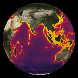
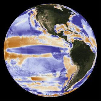
Sea Around Us and William Cheung of the Changing Ocean Research Unit at the UBC Fisheries Centre have transformed two datasets into planetary datasets as part of the NOAA Science on a Sphere educational initiative (sos.noaa.gov/).
 While these data had been previously published in the scientific literature (Cheung et al. 2009, Fish and Fisheries 10(3): 235-251; and Cheung et al. 2010, Global Change Biology 16: 24-35), this innovative spherical visualization option provides for a truly global perspective for viewers at institutions equipped with such a data sphere (such as the Smithsonian National Museum of Natural History, NASA’s Space Flight Center and other NASA centers, NOAA’s headquarter and other NOAA installations, and over 100 other installations around the world).
One dataset shows the predicted global distributions of over 1,000 marine species important for fisheries (Cheung et al. 2009, Fish and Fisheries 10(3): 235-251). Areas on the map colored more brightly highlight areas with higher species richness, while less brightly colored areas show lower species richness. This map shows the highest species richness is concentrated along the coasts, which are also the areas where we find our largest marine ecosystems, such as coral reefs, mangroves, and marshes, which provide food and shelter for economically, culturally, and ecologically important marine species. This stresses the importance of protecting critical habitat along our coasts for marine life and fisheries.
The second dataset illustrates the percentage change in global fisheries catch projected to occur by 2050 due to climate change (Cheung et al. 2010, Global Change Biology 16: 24-35). These data suggests a poleward shift in potential fisheries catches — that is fish distributions will shift to higher latitude areas (towards poles) and cooler waters as ocean temperatures increase. The study also predicts species extinction to occur in areas where species are most sensitive to temperature changes (i.e., tropical areas), resulting in reduced fisheries catch in these areas.
These and over 400 other global datasets and visualizations are shared through over 100 of the National Oceanic and Atmospheric Administration’s (NOAA’s) Science on a Sphere affiliated institutions around the world.
You can access the Fisheries Species Richness map here and the Fisheries Catch Model here.


