Bigger Is Better When It Comes to MPAs

Read about potential economies of scale in marine protection in this piece at Nature, which highlights work by Sea Around Us Project members Ashley McCrea Strub and Daniel Pauly that they presented at IMCC in May.

A postdoc in Pauly’s lab, Ashley McCrea Strub, has calculated that, worldwide, today’s marine protected areas cost US$2 billion a year to run at full capacity. That compares, she says, with $16.2 billion a year spent on ‘negative subsidies’ that encourage fisherman to fish more rather than less — subsidization of fuel costs, for example. On Sunday, McCrea Strub told the conference that if larger marine reserves accounted for a larger percentage of the total area protected — 10% instead of 1% — the costs of managing these would come to 83% less a year.

How Much Is that MPA in the Ocean?

Dr. Ashley McCrea-Strub, a post-doc with the Sea Around Us Project, is lead author of a study quantifying the costs of establishing marine protected areas, finding that managers have spent a wide ranging $41 – $1.1 million per square kilometer to get new reserves up and running. Studies have been done in the past that look at costs of running MPAs (such as this by 2010 article Cullis-Suzuki & Pauly) but this is the first attempt to quantify the cost of establishing MPAs in the first place. For more on McCrea-Strub’s work, read popular coverage of the work at Conservation Magazine or the full article at Marine Policy.

Satellite Imagery Can Improve Ocean Data

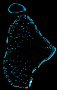
MaleAtollHow much the oceans are protected?   How much of the globe is covered in coral reefs?  These are important questions that require decent data.  A new study led by Sea Around Us Project member Colette Wabnitz and just released online by the journal Frontiers in Ecology and the Environment reveals that the current data available are too poor for them to be used to evaluate progress toward conservation targets, such as international goals to set aside 20-30% of the oceans as marine protected areas.  Technological advances in satellite imagery, like this image of the North Male atoll in the  Maldives, can help us better determine the true size of coral reefs, mangroves, seagrass, spawning grounds, and other vulnerable marine habitats.  Read the full study here.