 As devastating images of oil in the Gulf of Mexico streamed across virtually every media outlet during the months following the explosion of the Deepwater Horizon on April 20th, 2010, many experts in the fields of marine ecology and fisheries science have found themselves faced with the question, “What will be the impacts of this disaster?” As a native of South Florida with memories of family vacations to Gulf-coast beaches and an appreciation for delicious Gulf seafood, I have been eager to participate in any efforts to better understand the problem.
Attempting to answer this question is no simple task. Estimates of the quantity of oil, natural gas and associated methane, and chemical dispersants released into the Gulf of Mexico are plagued by uncertainty. The U.S. government-appointed team of scientists, a.k.a. the Flow Rate Technical Group, estimated that a total of 4.9 million barrels of oil were released from BP’s Macondo well [1] while an independent study suggested between 4.16 and 6.24 million barrels [2]. According to BP’s records, approximately 1.8 million gallons (i.e., about 6.8 million litres) of dispersant were applied at the site of the leak as well as the sea surface, though the validity of this amount has been questioned [3]. Complex oceanographic processes have made it extremely difficult to determine the current and future distribution of these toxic substances from the surface to the sea floor, and the duration of their persistence in the marine environment. Most importantly, there are no immediate answers to questions concerning short- and long-term impacts on habitats and marine organisms in the path of this disaster. This uncertainty is particularly troubling for fisheries dependent on economically valuable species.
Despite the geographic distance separating the Fisheries Centre from the Gulf of Mexico, the databases developed by the Sea Around Us Project provide a unique opportunity to explore potential effects of the spill on commercial fisheries in this Large Marine Ecosystem (LME). While these databases supply detailed information on a global scale, they may be easily queried to understand trends occurring in smaller geographic regions, such as the Gulf of Mexico. Using data detailing the location and quantity of species reportedly caught by fishers throughout the Gulf [4], in addition to information regarding the price that they receive when they sell their catch [5], spatial maps illustrating recent trends in catch and landed value were generated for this study.
From 2000 to 2005, an average of approximately 850,000 tonnes of fish, crustaceans, molluscs and other invertebrates, primarily inhabiting the highly productive continental shelf area, were commercially caught in the Gulf of Mexico. The majority of this catch originated within the 200 nautical mile limit of the United States’ Exclusive Economic Zone (EEZ), followed by landings within Mexican waters. The total landed value of this catch was estimated at approximately $1.38 billion US.
As oil slicks visible on the sea surface grew in size following the spill, the U.S. National Oceanographic and Atmospheric Administration (NOAA), as well as the States of Florida, Alabama, Mississippi and Louisiana, declared portions of federal and state waters closed to commercial fishing in an effort to promote seafood safety and ensure consumer confidence. The location of this closed area in relation to mapped average catch and landed value was analyzed to provide clues regarding potential economic losses to commercial fisheries in the region.
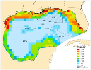
As of July 22, 2010, over 10% of the total surface area of the Gulf and nearly 25% of the US Gulf EEZ was closed to commercial fishing operations. Figure 2 demonstrates that this closure overlapped with highly productive and economically valuable shelf habitats accounting for 18% of the total annual value of reported commercial landings within the Gulf of Mexico LME. This represents a potential annual loss of $247 million to be suffered by U.S. commercial fishers. While the majority of US catch within the closed area during 2000 to 2005 was composed of Gulf menhaden, landings of brown and white shrimp generated the greatest value (12% of the annual US total in the Gulf, combined) due to high consumer demand and associated prices, followed by blue crabs (4%), Gulf menhaden (3%), and eastern oysters (1%). Potential impacts on valuable invertebrate fisheries may be compounded by the fact that relatively immobile, benthic organisms are likely to suffer higher rates of mortality as a result of the toxic effects of oil compared to more mobile fish species [6]. In addition, the capacity of habitats and species to recover from the effects of oil, methane, and dispersants may have already been compromised due to pre-existing sources of stress, including nutrient-laden freshwater discharge from the Mississippi River resulting in periodic oxygen-depleted ‘dead zones’, and bottom habitat destruction due to extensive shrimp trawling.
While this study does not attempt to address the full range of biological and economic consequences of the Deepwater Horizon oil spill on fisheries in the Gulf of Mexico, it does provide a preliminary perspective on one aspect of the puzzle, given pre-oil spill trends. It is evident that the oil spill has clearly impacted an area of crucial economic importance within the Gulf of Mexico.
During the months following the spill, my head has been filled with nostalgic thoughts of flour-like sand squeaking beneath my feet while playing on the beaches of Seaside, Florida, hours spent searching the seashore in Captiva for the beautiful shells that still sit in a bowl in my living room, and devouring a 10 lb bag of steamed clams bought from a fishers by the side of the road in Cedar Key. How will future generations of vacationing families, Gulf-coast residents and fishers remember this region? Hopefully, expectations of environmental resilience along with a continued dedication to clean-up operations will facilitate a swift recovery.
References:
1.http://www.restorethegulf.gov/release/2010/08/02/us-scientific-teams-refine-estimates-oil-flow-bps-well-prior-capping
2. Crone TJ, Tolstoy M (2010) Magnitude of the 2010 Gulf of Mexico Oil Leak. Science 330:634.
3. http://www.ens-newswire.com/ens/aug2010/2010-08-02-091.html
4. Watson R, Kitchingman A, Gelchu A, Pauly D(2004) Mapping global fisheries: sharpening our focus. Fish and Fisheries 5: 168-177.
5. Sumaila R, Marsden AD, Watson R, Pauly D (2007) A global ex-vessel fish price database: construction and applications. Journal of Bioeconomics 9: 39-51.
6. Teal JM, Howarth RW (1984) Oil spill studies: a review of ecological effects. Environmental Management 8: 27-44.
Figure: Spatial distribution of the average (2000-2005) annual landed value of reported commercial fisheries catches in the Gulf of Mexico LME. The area closed to commercial fishing (including both federal and state within the US EEZ as of July 22nd 2010) accounts for approximately 18% of the total value of landings within the LME. The remainder of the US EEZ still open to fishing accounts for 56%, while Mexican waters account for 26% of total landed value. Less than 0.1% of the annual landed value is derived from the two High Seas areas and Cuban waters.
This article written by Sea Around Us post-doctoral fellow Ashley McCrea-Strub and appears in the newsletter.
 More than 20 top marine ecologists gathered last week in Belize City to review the status of the country’s marine biodiversity and the potential impacts an oil spill could have on local marine ecology. After the meeting, the participants unanimously agreed that the Belize government should prohibit offshore oil drillings in Belize’s waters, a referendum that will be voted on in late 2011.


